Simulation Data Output
Output Datafile Format
OpenSWPC can export two types of data: spatiotemporal snapshots along 2D profiles and
the seismic waveform at stations.
For snapshot files, the user may choose from an originally defined
binary format (obsolete and not recommended) or a NetCDF file (recommended). The waveforms are usually exported in SAC format. Optionally, users can choose the CSF format which is concatenated SAC data into s single binary file.
The endian conversion is not performed at the time of the data output. Notice that the official libraries of NetCDF and SAC automatically detect the endian format and convert them if necessary. Therefore, users do not have to worry about the
differences in endian formats between machines.
Note that the horizontal component directions for both waveforms and snapshots correspond to the , , and of the calculation coordinate system. If phi=0, then and are north and east, respectively, but care is needed if the calculation coordinate system has been rotated (if phi is not zero).
The rotation angle of this coordinate system is stored in the cmpaz field of the SAC file header for waveform output, so it can be easily converted to a direction where north and east are positive in post-processing. In addition, in OpenSWPC, the vertical coordinate is positive downward, but in the waveform output, it is reversed so that it becomes positive when it is upper, following to the habit of observational seismology. On the other hand, the component of the velocity output of the snapshot remains in the calculation coordinate system (positive when it is lower).
Header information of the waveform files
For SAC files, the header components
described in the following table are automatically set. The units of SAC files
are nm/s for velocity and nm for displacement, following the standard of
SAC. While the earthquake source may be represented by multiple point
sources, the header always represents the source listed in the first
line of the source input file.
| header name | description |
|---|---|
kevnm |
title of the parameter file |
evlo, evla, evdp |
The location of the event (in degrees for horizontal, in m for depth).If the loctaion is given in the Cartesian coordinate, a map projection is perfomed with parameters clon and clat. |
o |
Origin time of the event listed in the first line of the source list |
kzdate, kztime |
Date and time of the execution of the simulation code |
b |
tbeg of the parameter file |
delta |
ntdec_w dt |
mag |
The moment magnitude converted from the seismic moment |
user0,..., user5 |
Moment tensor () of the first line of the source file |
user6, user7, user8 |
clon, clat, phi of the parameter file |
kstnm |
stnm of the parameter file |
stlo, stla, stdp |
Station location (in degrees for horizontal, in m for depth). If the loctaion is given in the Cartesian coordinate, a map projection is perfomed with parameters clon and clat. |
kcmpnm |
Vx, Vy, Vz for velocities or Ux, Uy, Uz for displacements |
cmpinc,cmpaz |
Station directions according to the coordinate specification |
idep |
7 for velocity, 6 for displacement |
Header of the Snapshot
The snapshot file contains the header information listed in the following table. These headers are commonly defined in either original format or NetCDF. For both file formats, the utility program read_snp.x can be used to read them.
| var name | type | description |
|---|---|---|
bintype |
character(8) | Fixed to "STREAMIO" |
codetype |
character(8) | SWPC_3D, SWPC_PV, or SWPC_SH depending on the code |
hdrver |
integer | Header version |
title |
character(80) | title in the parameter file |
exedate |
integer | Date and time of the execution in POSIX time |
coordinate |
character(2) | Snapshot cross section: 'xy', 'xz', 'yz', 'fs', or 'ob' |
datatype |
character(2) | Data type: 'ps' or 'v2' or 'v3' |
ns1,ns2 |
integer | Number of data samples along the first and second axes |
beg1,beg2 |
real | Coordinate value at the first data point of the axes |
ds1,ds2 |
real | Snapshot grid spacing |
dt |
real | Time step width of the snapshot |
na1,na2 |
real | Grid numbers of the absorbing boundary layer in the snapshot |
nmed |
integer | Number of stored medium parameters |
nsnp |
integer | Number of snapshots per time step |
clon,clat |
real | clon, clat in the parameter file |
v1,v2,v3 |
real | Currently not being used |
Change in a SAC header
evdp is measured in a unit of km after OpenSWPC version 5.0, while it was in m unit previously.
For NetCDF, these headers are set as global attributes. The other
headers are set following the COARDS Conventions and the CF
Convention. Thanks to these rules, output NetCDF files of OpenSWPC can be directly read by many scientific visualization tools, such as ParaView, Panoply or GMT.
Snapshot Data Output
Spatiotemporal snapshot output may be created along cross sections of
xy, yz, and xz profiles on the topography (fs) and/or on the
bathymetry (ob). There are three types of snapshots: divergence and
rotation of the velocity (ps), velocity (v), and displacement (u).
The use of spatial and temporal decimations is recommended to reduce the
I/O load and export data size. Decimation in time is specified by
ntdec_s starting from it=0 (before starting the computation). In
space, the decimations are performed by factors of idec, jdec, and
kdec, and OpenSWPC tries to export the center of the decimation
window, as schematically shown in the following figure.
The numbers of exporting grids in each MPI
node do not necessarily need to be the same for each node. The
amplitudes of these snapshot points will be gathered to specific nodes and exported as single files.
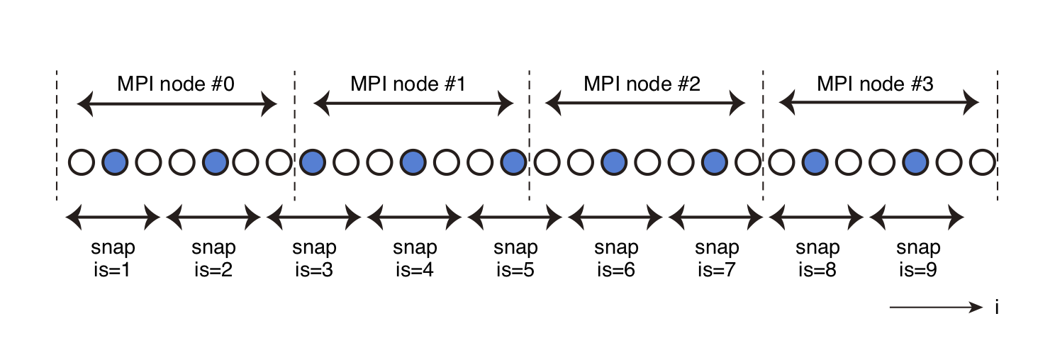
Schematic of the spatial decimation for the snapshot output. The vertical dotted lines show the borders of the MPI nodes. In this example, the data at the blue grids will be exported as the snapshot data.
Parameters
snp_format- Datafile format of the snapshot files:
"native"(original binary format; obsolete) or"netcdf"(recommended). Although theNetCDFfile format is recommended for convenience in data handling, the use of this format may lead to a slight ( 10 %) increase in computation time. xy_ps%sw,xz_ps%sw,yz_ps%sw,fs_ps%sw,ob_ps%sw- Flags for exporting snapshot files of the PS files (
.true.or.false.). If they are set to.true., the divergence and rotation vector of the particle velocity will be exported. xy_v3%sw,xz_v3%sw,yz_v3%sw,fs_v3%sw,ob_v3%sw- Flags for exporting snapshot files of the velocities.
xy_u3%sw,xz_u3%sw,yz_u3%sw,fs_u3%sw,ob_u3%sw- Flags for exporting snapshot files of the displacements.
z0_xy- Depth (km) of the snapshot cross section.
x0_yz- X-coordinate value (km) of the snapshot cross section.
y0_xz- Y-coordinate value (km) of the snapshot cross section.
ntdec_s- Temporal decimation factor of the snapshot output. Snapshots will be
exported every
ntdec_stime steps. idec,jdec,kdec- Spatial decimation factor of the snapshot output for the , , and directions.
Seismic Waveform Output
Seismic velocity and/or displacement records at specified stations can
be obtained as SAC-formatted files or its derivative by setting the parameters sw_wav_v
and/or sw_wav_u to .true.. Displacement records are calculated
before the decimation, and therefore, they are expected to be more
accurate than performing a numerical integration of the output velocity
records. The traces are stored in the memory during the computation and
are exported at the end.
Station Location Specification
Station locations are given in Cartesian coordinates (xy) or
geographical coordinates (ll), as in the following table.
In the station list, lines starting with # will be ignored.
| Type | Format |
|---|---|
'xy' |
x y z name zsw |
'll' |
lon lat z name zsw |
The depth of the station can be changed depending on the variable zsw in
the station list, as shown in the next table. T
zsw |
Station depth setting |
|---|---|
’dep’ |
Calculate the station location from the given station depth |
’fsb’ |
One grid below the free surface (for oceanic areas, the sea surface) |
’obb’ |
One grid below the ocean bottom (seafloor) or ground surface |
’oba’ |
One grid above of the ocean bottom (seafloor) or ground surface |
’bdi’ (i=0, \cdots, 9) |
Internal velocity discontinuity specified by the velocity model |
This operation is important because the
station near the free surface is occasionally located above the
approximated ground surface in air due to the staircase approximation of
the topography and bathymetry. Usually, it is recommended to set
zsw=’obb’; this setting locates stations one-grid level below the
ground surface (or seafloor).
Multiple stations can be specified in the station list file. There is no fixed limit on the number of stations. The number of stations is automatically counted, and only the stations inside the computational region will be exported.
Output Data Format of Waveofmrs
The data output format for seismic waveform data is SAC format. However, since SAC files are one file per station per component, if multiple waveforms for multiple stations are output, the number of files will become huge and it will be difficult to handle. Thus, it is also possible to output a file that combines the waveforms for each station or each calculation node into a single tar archive (New in Version 25.01).
For OpenSWPC version 3.0 or later, users
can choose a concatenated SAC format (csf) for the data output by
specifying wav_format=’csf’. This is a set of SAC binary files
connected to a single file, with headers as in the following:
CSF header format
identifier- Fixed to 'CSFD'
ntrace- Number of traces in the file
npts- Number of samples in a trace
It is assumed that the number of samples (ntpts) are in common in the csf format. If the csf format is selected, each parallel computation node exports waveforms in the corresponding domain into csf files for every components.
Exporting large number of waveform dataset
Large-scale computer systems often adopt the parallel lustre file system, which is not good at treating small but many files such as seismic wave traces in SAC format. In this case, it is recommended to use concatnated CSF format.
Note
As tar archives are more flexible than csf archives, the csf format is deprecated and will be removed in future versions.
wav_calc_dist parameter and lcalda headers
Up to version 24.09, when the wav_calc_dist option was .true., the horizontal distance in the calculation coordinate system was stored in the SAC header as the epicentral distance. From version 25.01 onwards, the epicentral distance is always stored, and the lcalda header is set to .false. so that the SAC does not overwrite the distance. As a result, the parameter wav_calc_dist has been deprecated.
Strain and stress output
By specifying sw_wav_strain = .true. and sw_wav_stress = .true., users can obtain strain and stress time series as a SAC-formatted data file as in the case of velocity and displacement (Experimental; new in version 5.0). The specification of station locations are same with the case of velocity/displacement. The output units are nondimensional for strain and [Pa] for stress data.
Timing of waveform output
The seismic waveforms at the stations are stored in memory during the computation and are output to a file at the end of the computation. However, if the parameter ntdec_w_prg is set to an integer greater than or equal to 1, waveforms can be output at each time step of that number. The length of the waveform is always the length determined by nt, and the part of the waveform that has not been computed yet is filled with zeros. This function is intended to monitor the normality of the computation during the computation, but it should be noted that if ntdec_w_prg is set too small, the computation time may increase due to the output load. If the value of ntdec_w_prg is less than or equal to 0, the waveform is output only at the end of the computation.
Parameters
sw_wav_v,sw_wav_u,sw_wav_strainsw_wav_stress.true. for exporting velocity (sw_wav_v), displacement (sw_wav_v), strain (sw_wav_strain) and stress (sw_wav_stress`) traces.ntdec_w- Decimation factor of the waveform output. For
ntdec_w=1, traces at every computational time step will be exported.
st_format
:Format of the station list file. See the above table.
fn_stloc- Station location filename.
wav_format- Waveform file format. Specify one of
'sac','tar_st', 'tar_node', or'csf'.tar_stoutputs atararchive file that contains waveforms for each observation point, andtar_nodeoutputs atararchive file that contains waveforms for each calculation node. ntdec_w_prg(New in Version 24.09)- Output timing of waveform during calculation. Outputs waveform at every time step specified in this parameter. If it is less than or equal to 0, waveform is not output until the end of calculation.
Computation Time Output
To analyze the performance of the code, the computation time of each block can be measured. This file can be visualized by using the tools/timvis.gmt script.
Parameters
stopwatch_mode- Output switch for the computation time. If
.true., the computation time for each subroutine is output.
Output Filename Conventions
Output data names are determined by the following rules:
- Snapshot
(odir)/(title).(code).(section).(type).(ext) - Waveform (SAC)
(odir)/wav/(title).(code).(stnm).(component).sac - Waveform (CSF)
(odir)/wav/(title).(node-ID).(component).csf - Waveform (TAR-ST)
(odir)/wav/(title).(code).(stnm).tar - Waveform (TAR-NODE)
(odir)/wav/(title).(code).(node-ID).tar - Computation time
(odir)/wav/(title).tim
In the above rules, (section) takes a cross section such as xy or
yz. (type) takes v or ps depending on the snapshot data type.
(component) takes Vx, Vy, or Vz for the velocity or Ux, Uy, or Uz for
the displacement. Extension of the snapshot ext will be nc for NetCDF and snp for the native format.